Kildoo Trail – McConnells Mill State Park

Slippery Rock Creek along Kildoo trail
Trail Info:
Location: The trail entrance is just to the left of the red-covered bridge at McConnells Mill State Park.
Difficulty: Moderate, lots of short up and down slopes, tons of rocks on and around the trail.
Rating (out of 5): 4.9
Trail Characteristics:
- ~ 1 mile one way, 2 miles round trip
- Follows the Slippery Rock Creek from McConnells Mill to Eckert bridge. One side of the trail is the creek, and the other is a steep slope littered with large rocks.
- The North Country trail follows the other bank of the Slippery Rock creek.
- A thin semi-paved trail that begins with a smooth walking surface and leads way to an uneven rocky path.
- Some water on the trail, but passable in most areas without getting your feet wet.
- Swimming in the creek is not allowed!
- The creek helps temper the heat on hot days.
- Yellow trail markers.
Directions on PCs: Locate the Google map below the search box on the right-hand side of this webpage. Click “Get Directions” on the map pin details.
Directions on Tablets and Mobile Phones: Locate the Google map near the bottom of this page, just below the search box. Click “Get Directions” on the map pin details.
Trail Map:

Trail Photos:

The trail starts off very easily with a paved portion. The creek is constantly visible on the right and the terrain has a steep slope on the left. Large rocks can be found on both sides.


A small crick flows under a bridge on Kennedy Road in the far background of the photo above. There is a short path leading in the direction of the falls, but I didn’t decide to check it out this trip.

Soon the trail turns from paved to more of a natural path, complete with rocks, roots, and occasional streams.
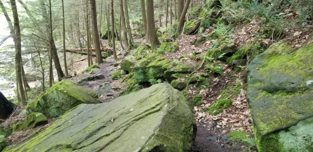


The trail is never far from the Slippery Rock creek, in fact, it is always visible if you stay on the trail, and forms a large portion of the interesting things to look at.

You can get a hint of how high the water gets during flooding by looking at where debris are left. Above a tree trunk, was left on the side of a rock at least 4 or 5 feet above the current water line. You can guess the water was a bit higher in order to deposit the tree trunk as shown.


When you get to the second thin waterfall you are almost to the end of the trail at Eckert bridge. I’ve since learned there is a trail on the other side of the bridge that may hold some pretty interesting scenery, so I look forward to posting pictures of it in the future. If you do venture that way, leave me a comment about what’s on the other side!


